MAP-VERSE
  • Homepage
  • About
  • Keywords
  • Tools
  • License
  • Search
MAP-VERSE

Search MAP-VERSE

Eye Movement Dataset


GeoEye

BNU500 A geospatial image based eye movement dataset for cartography and GIS

Abstract

A geospatial image-based eye movement dataset called GeoEye, a publicly shared, widely available eye movement dataset. This dataset consists of 110 college- aged participants who freely viewed 500 images, including thematic maps, remote sensing images, and street view images, which could use for geospatial image saliency prediction and map user identification.

Full citation (dataset) with DOI

HE, ICE (2021). GeoEye dataset. figshare. Dataset. https://doi.org/10.6084/m9.figshare.14684214.v4

Related articles

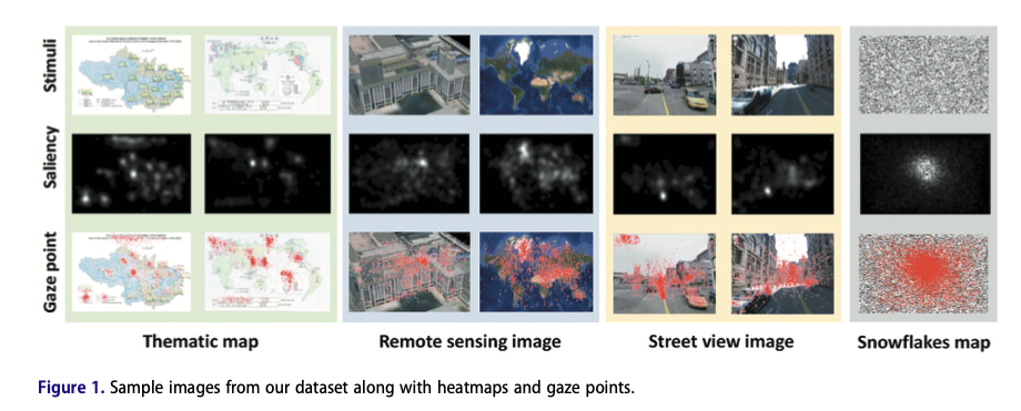
He, B., Dong, W., Liao, H., Ying, Q., Shi, B., Liu, J., & Wang, Y. (2023). A geospatial image based eye movement dataset for cartography and GIS. Cartography and Geographic Information Science, 50(1), 96–111. https://doi.org/10.1080/15230406.2022.2153172

Related links

https://www.tandfonline.com/doi/full/10.1080/15230406.2022.2153172

/Repository/img/img01.jpg
eye movement dataset  geospatial image  cartography  GIS  visual saliency detection 

Cartographers & GISers  • © 2024 - 2025  •  MAP-VERSE

Hugo v0.130.0 powered  •  Theme Beautiful Hugo adapted from Beautiful Jekyll